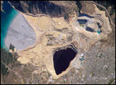
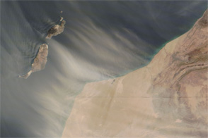
Saharan dust blew off the west coast of Africa and over the Canary Islands on November 11, 2006. The Moderate Resolution Imaging Spectroradiometer (MODIS) flying onboard NASA’s Terra satellite took this picture the same day. In this image, parallel plumes of pale beige dust blow off the coasts of Morocco and Western Sahara. The “lines” of dust are more distinct off the coast of Morocco than off the coast of Western Sahara, where the dust plumes are more amorphous. The dust from Morocco may originate from more discrete source points, separated by areas with little or no loose dust that can easily be lifted by wind. Regardless of their shape, all the plumes blow toward the northwest, and although the islands of Tenerife and Gran Canaria appear unaffected, the neighboring islands of Fuerteventura and Lanzarote are receiving a strong dose of dust. Fringing the edges of this image are fluffy white clouds. It is possible that the same weather system associated with the cloud cover in this image has produced the winds that move the dust.
The Sahara Desert produces a steady supply of dust, and the Canary Islands prove frequent targets. Saharan dust often travels much farther than these islands; it often crosses the Atlantic and reaches islands in the Caribbean where it proves to be a mixed blessing. While heavy doses of dust can damage coral reefs, the same dust supplies soil to islands that would otherwise be barren rock.
A 250-meter-resolution KMZ file of the dust blowing over the Canary Islands is available for use with Google Earth.NASA image courtesy Jeff Schmaltz, MODIS Rapid Response Team, Goddard Space Flight Center