This page contains archived content and is no longer being updated. At the time of publication, it represented the best available science.
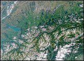
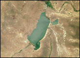
Here’s another chance to play geographical detective! This natural-color image from the Multi-angle Imaging SpectroRadiometer (MISR) represents an area of about 473 kilometers by 372 kilometers, and was captured by the instrument’s vertical-viewing (nadir) camera in March 2004. Use any reference materials you like and answer the following 4 questions.
NOTE: To make identification of this scene more difficult, the image has been rotated such that North is not necessarily at the top.
Situated below and to the right of image center there is a distinctive round lake with the small interior island off to the side of it. Three of the following four statements about the lake are true. Which one is false?
The clarity of the water in that round lake is very good because the water does not come from surface catchments, but from rainfall or snow that fell directly into the lake and accumulated over time.
The lake is the result of a volcanic eruption that was recorded in oral history and legends from the area.
The small interior island was named for its resemblance to a particular style of head-wear.
Soundings of the lake show that it is the deepest lake on the continent in which it is found.
Three of the following four statements concerning the landscape of the region are true. Which one is false?
Amid the snow-capped mountains near image center there is a collection of many lakes, some of which are remain partially covered by ice throughout the year.
In the lower right-hand corner is a large tan patch that is surrounded by the deep green forested areas. This large tan area indicates relatively bare soil and scarce vegetation resulting from the large forest fires that occurred there in 2002.
Between about 30 and 80 kilometers above and to the right of the distinctive round lake there are several brown, irregularly shaped dark brown patches that contrast with the tan hue that dominates this part of the landscape. Those brown areas are burn scars from fires that took place throughout the region in 2003.
The many small tan areas that appear like a patchwork pattern among the green forests in the lower portion of the image area indicate logging activities. Only about 10 percent of the forested ecoregion within the lower right-hand portion of the image is legally protected from logging.
Three of the following four statements related to energy sources within the image area are false. Which one is true?
There is an active uranium mining site within the image area.
Coal has been in continuous production since the 1950s at a coal mine situated in the lower-left-hand image corner.
The first hydroelectricity power-generating station within the image area was not established until the first decade of the 20th century.
In the lower-right-hand corner of the image area there is a well drilled for the purpose of harnessing geothermal energy that is more than 500 meters deep.
Three of the following four statements about the ecology and geology of the region are true. Which one is false?
In the upper-right-hand image corner there are several large, shallow, closed-basin alkaline lakes that support brine shrimp and other aquatic invertebrates that in turn supply food for millions of migratory birds.
Throughout this region around water bodies and rivers there are many known breeding locations for large birds of the genus Haliaeetus.
Within the lower half of the image area there is a lava-tube in which the longest uncollapsed segment measures more than three kilometers long.
In the upper-left-hand part of the image there is a landscape that, due to ancient lava flow, remains almost entirely devoid of vegetation over an area of about 1,600 acres. That region was used as an analogue for an extraterrestrial environment during scientific simulation studies during the 1960s.
Quiz Rules
Send us your answers, name (initials are acceptable if you prefer), and your hometown by the quiz deadline of Tuesday, December 6, 2005, using the Quiz answer form. Answers will be published on the MISR web site. The names and home towns of respondents who answer all questions correctly by the deadline will also be published in the order responses were received. The first 3 people on this list who are not affiliated with NASA, JPL, or MISR and who have not previously won a prize will be sent a print of the image.
A new “Where on Earth...?” mystery appears as the MISR “latest featured image” approximately once every two to three months. New featured images are released on Wednesdays at noon Pacific Time on the MISR home page. The image also appears on the Atmospheric Sciences Data Center home pages, although usually with a several-hour delay.
MISR was built and is managed by NASA’s Jet Propulsion Laboratory, Pasadena, CA, for NASA’s Office of Earth Science, Washington, DC. The Terra satellite is managed by NASA’s Goddard Space Flight Center, Greenbelt, MD. JPL is a division of the California Institute of Technology.
Image courtesy NASA/GSFC/LaRC/JPL, MISR Team. Text by Clare Averill (Raytheon ITSS/JPL) and Shirley Mims (Glendale Community College/JPL).
Where on Earth...? Follow the clues to figure out what geographic region is shown in this image, and then answer the questions about the place for a chance to win the MISR Mystery Image contest.