
Autumn usually marks a relatively dry time of year for the region surrounding St. Louis, but the autumn of 2009 brought heavy rains and swollen rivers. The Associated Press reported that heavy rains in late October left thousands of acres of farmland under water, especially in the flat lands of southern and western Illinois, near the Illinois, Ohio, and Kaskaskia Rivers. In early November 2009, the National Weather Service recorded major flooding along the Illinois River.
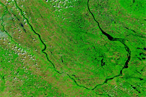
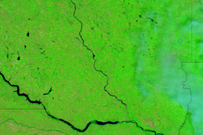
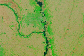
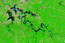
The Moderate Resolution Imaging Spectroradiometer (MODIS) on NASA’s Terra satellite captured these false-color images before and after the storm that flooded the region. The top image is from November 4, 2009, and the bottom image is from October 24, 2009. Both images use a combination of infrared and visible light to increase the contrast between water and land. Vegetation appears bright green, water appears navy blue, and clouds appear pale blue-green.
In the image acquired November 4, the Mississippi River appears swollen near St. Louis. Roughly 175 kilometers north of the city, the Illinois River is especially wide compared to the same area in late October. Due east of St. Louis, Carlyle Lake, along the Kaskaskia River, has also expanded. Smaller tributaries to the Illinois River also appear flooded.
East of the Illinois River, vegetation appears less abundant in early November. The change could be the advance of autumn and/or harvesting of agricultural fields, but differences in angle of sunlight (time of day) between the image acquisitions may also play a role.
NASA image courtesy MODIS Rapid Response Team, Goddard Space Flight Center. Caption by Michon Scott, NASA Earth Observatory.