New research sponsored by NASA may soon help scientists do a better job of tracking pollution plumes around the world and help provide people more advance warning of unhealthy air.
Researchers have discovered that smoke and smog move in different ways through the atmosphere. A series of unusual events several years ago created a blanket of pollution over the Indian Ocean.
In the second half of 1997, smoke from Indonesian fires remained stagnant over Southeast Asia while smog, which is tropospheric, low-level ozone, spread more rapidly across the Indian Ocean toward India.
Researchers tracked the pollution using data from NASA's Earth Probe Total Ozone Mapping Spectrometer (TOMS) satellite instrument. "TOMS is the only satellite instrument that follows both smoke and smog, globally," said Anne Thompson, NASA Earth Scientist at Goddard Space Flight Center, Greenbelt, MD. "The extreme pollution generated during the Indonesian fires was the first time we saw smoke move more slowly and in different directions from where smog moved."
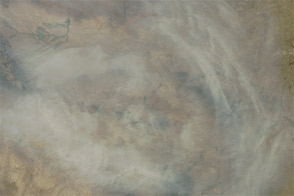
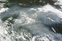
The above image shows the pollution over Indonesia and the Indian Ocean on October 22, 1997. White represents the aerosols (smoke) that remained in the vicinity of the fires. Green, yellow, and red pixels represent increasing amounts of tropospheric ozone (smog) being carried to the west by high-altitude winds.
For more information, images, and animations, read the on-line news release, and visit the TOMS home page and the tropical tropospheric ozone page.
Image courtesy NASA GSFC Scientific Visualization Studio, based on data from TOMS.