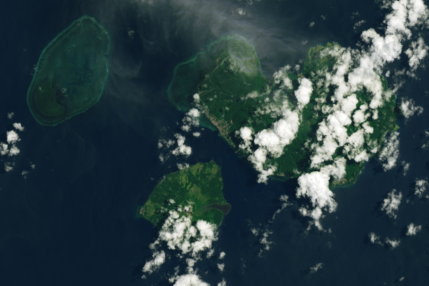

Ruang is a small volcanic island in the Sangihe Islands arc in North Sulawesi, Indonesia, that is home to about 800 people. Late on April 16, 2024, the mountain roared to life, unleashing a series of explosive eruptions that, at times, sent plumes of ash and gas billowing high into the stratosphere. The eruption also bombarded the island with tephra, small pebbles of lapilli, and fine shards of pulverized rock called ash.
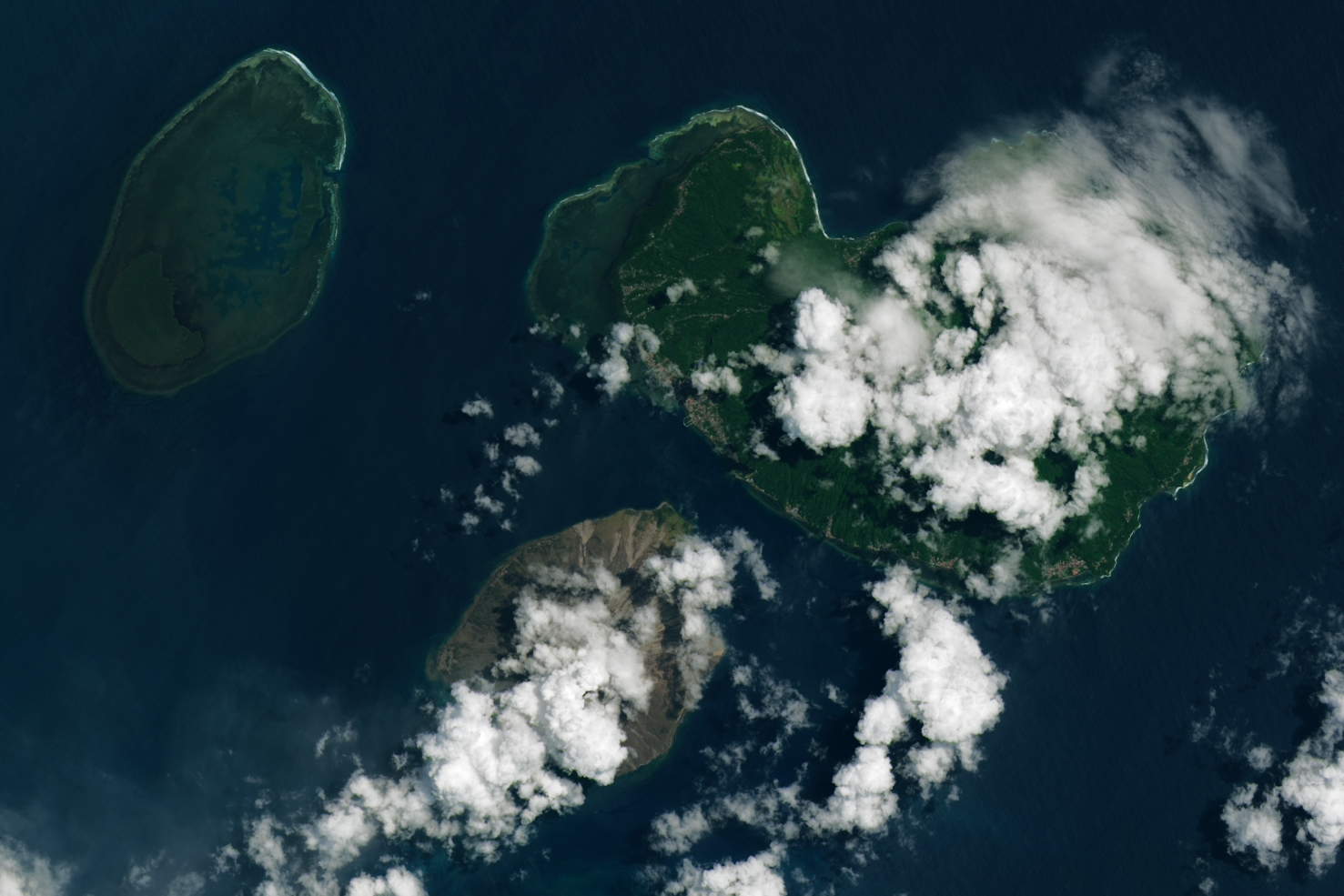
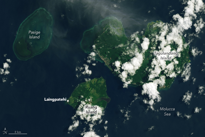
The pair of Landsat satellite images above highlights how the eruption transformed the landscape. The OLI-2 (Operational Land Imager-2) captured an image on April 12 (left) that shows Ruang’s lush green vegetation before the eruption; the OLI (Operational Land Imager) image, acquired on April 20 (right), shows the same area after volcanic debris had blanketed the island. The image also shows signs of pyroclastic flows—destructive torrents of hot ash, rock, soil, and gas—that poured down the mountain’s slopes and left thick deposits at the base.
Settlements on the north side of the island were among the hardest hit with volcanic debris. On the west side, tephra also blanketed Laingpatehi, the island’s largest village. The bright white features obscuring parts of the island are likely passing clouds, though some of them could be volcanic plumes emitted by the still-active volcano.
According to initial assessments by Badan Nasional Penanggulangan Bencana (BNPB), Indonesia’s disaster management agency, heavy ashfall and volcanic rock fragments severely damaged or destroyed more than 500 houses. It also damaged crops and farms.
The ash posed a hazard to aviation, prompting widespread flight cancellations and diversions. Authorities closed the Sam Ratulangi International Airport in the nearby provincial capital of Manado due to the ash, disrupting travel for thousands of people. The airport reopened on April 22, after rainfall washed away ash on the runway, and after BNPB had lowered the volcanic alert level.
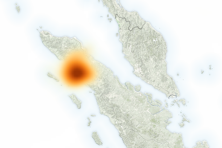
A geostationary satellite operated by the Japan Meteorological Agency and polar-orbiting satellites operated by NASA and NOAA all observed ash and sulfur dioxide streaming from Ruang as the volcano erupted.
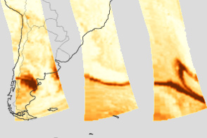
According to Ghassan Taha, an atmospheric scientist at NASA’s Goddard Space Flight Center, data from the Ozone Mapping and Profiler Suite (OMPS) Limb Profiler (LP) show that the volcanic plume reached an altitude of about 20 kilometers (12 miles) and into the stratosphere, the second layer of the atmosphere above the ground. Atmospheric scientists monitor the amount of particles and gases that volcanoes inject into the stratosphere because material reaching this height can spread widely and have global effects on the climate.
“We expect to see aerosol particles circulating in the stratosphere for weeks, if not months,” Taha said.
In recent decades, volcanic eruptions have injected material into the stratosphere about once a year. However, the injection of at least 5 teragrams of sulfur dioxide is generally required to produce enough aerosol particles to temporarily change the reflectivity of the upper atmosphere, according to climatologists. In most cases, the amount of material reaching the stratosphere has been modest and below that threshold.
After the eruption at Ruang, an infrared sensor on the geostationary Himawari satellite measured a total emission of about 0.5 teragrams of sulfur dioxide on April 17, according to Simon Carn, a volcanologist at Michigan Technological University. The following day, other satellites measured about 0.3 teragrams. “The actual sulfur dioxide emission was probably between 0.3 and 0.5 teragrams, well below the threshold for significant climate impacts,” Carn said.
The 1991 eruption of Mount Pinatubo in the Philippines, which caused a global cooling of about 0.5 degrees Celsius (0.9 degrees Fahrenheit) for about a year, released approximately 20 teragrams of sulfur dioxide into the stratosphere. More recently, the 2022 Hunga Tonga-Hunga Ha’apai eruption injected an estimated 0.5 to 1 teragrams.
Ruang, whose name means “space” or “room” in the local Bugis language, has a long eruptive history and is one of Indonesia’s most active and dangerous volcanoes. Major explosive eruptions have occurred in 1634, 1670, 1843, 1871, 1904, 1956, and 2002, according to the Global Volcanism Program. The 1871 eruption triggered a tsunami that devastated a village on a nearby island and caused hundreds of deaths.
Officials warned the 2024 eruption could trigger lahars—volcanic mudflows—as rain intermingles with fallen ash in the coming days and weeks. The eruption also raised fears of potential tsunamis from volcanic flows entering the sea, prompting multiple tsunami warnings, though no significant tsunamis have occurred, according to the local volcanic survey (PVMBG) and BNPB. Indonesian authorities coordinated the evacuation of over 16,000 residents from areas most at risk of pyroclastic flows, ash falls, and tsunamis. Since the eruption began, no deaths or injuries have been reported.
NASA Earth Observatory images by Michala Garrison, using Landsat data from the U.S. Geological Survey. Story by Adam Voiland.