The sea level concerns at Kennedy Space Center are the most visible, given the history and high profile of the real estate. But the issue touches the majority of NASA centers.
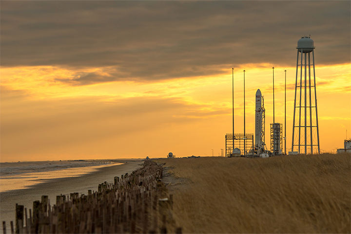
The beaches and dunes alongside launch facilities in Wallops Island, Virginia, have been built up, washed away, and built up again several times in the past decade. (Photo by NASA/Bill Ingalls)
NASA’s Wallops Flight Facility, carved out of coastal marshland on the eastern shore of Virginia, is most like Kennedy in its vulnerability. Wallops had a prominent role in the early days of spaceflight before settling into a quieter role for several decades. In the past fifteen years, the facility has been redeveloped for launching NASA and commercial rockets, including the 2013 LADEE mission to the Moon. In the process, at least $1 billion in new spaceflight infrastructure has been set down along Atlantic shores.
But Wallops sits amidst a barrier beach system, and those sand bars want to move. Erosion and beach migration has been reshaping the barrier island, Assateague, which sits north and east of Wallops. Assateague has been losing 10 to 22 feet (3 to 7 meters) of beach per year; Wallops Island has been losing about 12 feet. According to the Environmental Protection Agency, 50 acres (20 hectares) of surrounding Accomack County are turning from farmlands to wetlands each year.
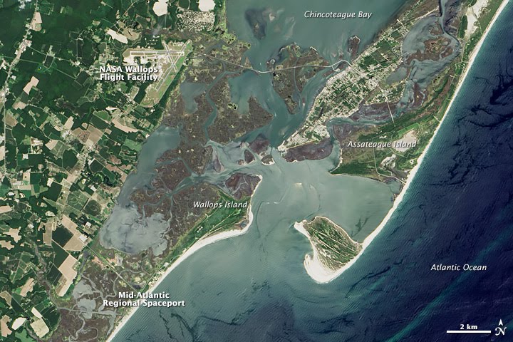
Barrier beaches near the Wallops Flight Facility and the Mid-Atlantic Regional Spaceport have been receding by as much as 12 feet per year. (NASA Earth Observatory image by Jesse Allen, using Landsat data from the U.S. Geological Survey)
Hurricane Irene in 2011 did substantial damage to Wallops, leading NASA and local partners to redouble their efforts to hold back the tide. Coastal engineers built a sea wall 14-feet high and 3 miles long. By the time they finished in August 2012, more than 3 million cubic yards of sand had been pumped up onto the beach, part of a $43 million beach restoration project. A few months later, Hurricane Sandy removed 20 percent of the sand that had just been placed. Another 10 percent washed away in the months that followed, and another $11 million had to be spent to fix the walls and the beaches.
Situated near the third largest seaport in the United States and the nation’s largest naval base (Naval Station Norfolk), NASA’s Langley Research Center has to fight both rising seas and sinking land. Scientists have found that sea level around the Chesapeake Bay has been rising at 0.13 inches (3.4 millimeters) per year, twice the global average of 0.07 inches (1.7 mm) per year.
Recent studies have shown that the landforms around the Chesapeake are sinking as a result of processes that started during the last Ice Age. When massive sheets of ice covered much of North America, the weight pressed down on Earth’s crust and mantle, causing subterranean, molten rock to bulge under the Chesapeake and other points south. When the ice retreated, northern lands began rising—rebounding—while the land to the south began subsiding again.
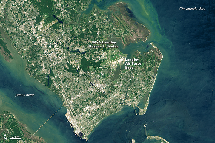
Langley Research Center is surrounded by water and sits on land that is still naturally subsiding from the last Ice Age. (NASA Earth Observatory image by Joshua Stevens, using Landsat data from the U.S. Geological Survey)
The combination of rising waters and sinking ground means the Hampton Roads area (Norfolk-Newport News-Virginia Beach) could see 41 to 53 inches (104 to 135 centimeters) of relative sea level rise by the 2080s. That prospect has the leaders of both NASA Langley and the Langley Air Force Base planning to slowly move back from coastal flood zones. Scientists have surveyed the property with airborne lidar, and modelers have looked more closely at future projections for flood-prone areas. Old buildings are being hardened for tougher weather, and new buildings are being sited farther inland.
Johnson Space Center lies within some of the most notorious hurricane territory along the Gulf of Mexico coast. The primary NASA center for human spaceflight training and operations is particularly vulnerable to water hazards, including storm surges from hurricanes, flooding from extreme rainfall, and sea-level rise. While these hazards are not new to the Galveston Bay region, many climate change scenarios predict increases in the frequency and severity of such events in an area where sea level rise has been significant. Sea level has been rising nearly 2.5 inches (6.4 centimeters) per decade in Galveston Bay, significantly more than at any other NASA center.
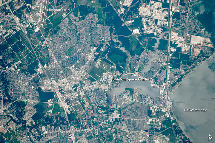
Sea level in Galveston Bay, near Johnson Space Center, has been rising nearly 2.5 inches (6.4 centimeters) per decade, significantly more than at any other NASA center. (Astronaut photograph ISS024-E-10403 provided by the ISS Crew Earth Observations experiment, Johnson Space Center)
Hurricane Ike in 2008 provided an instructive dress rehearsal for future events. Ike was just a category 2 storm in terms of wind speed, but the 20-foot-storm surge was similar to what a category 5 storm would generate. Widespread power outages occurred in Houston, and the power loss and debris cleanup resulted in a week-long shutdown at Johnson. The experience spurred improvements to infrastructure, including new floodgates at key facilities like Mission Control and the protecting and raising of utility tunnel vents to better handle storm surge flooding.
Then there is NASA’s home in New Orleans. Michoud Assembly Facility includes one of the world’s largest manufacturing plants, a 43-acre building where Saturn rockets and space shuttle boosters were once assembled and where the new Space Launch System will be pieced together. The facility provides deepwater access for ships that carry rockets across the Gulf of Mexico to Kennedy and Wallops.
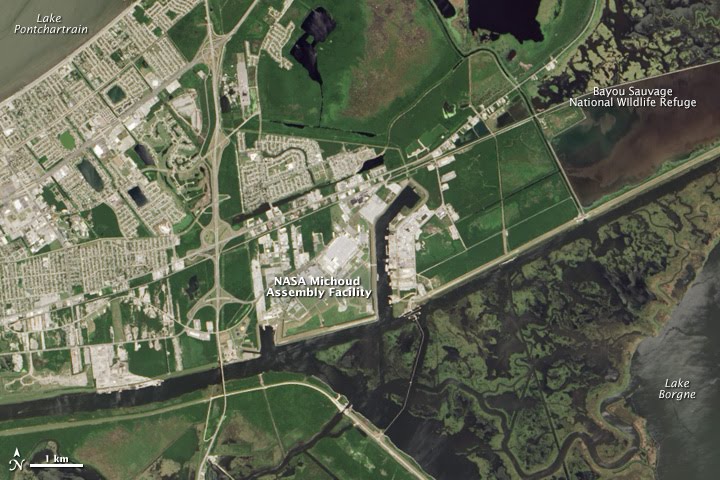
Situated in the bayous and marshes of the Mississippi Delta, Michoud Assembly Facility is experiencing significant ground subsidence that exacerbates sea level rise. (NASA Earth Observatory image by Jesse Allen, using Landsat data from the U.S. Geological Survey)
But Michoud stands below sea level and behind 19-foot-tall earthen levees. The land beneath the facility is subsiding, a result of the draining and compression of Mississippi Delta swampland as the city of New Orleans has been built up over the centuries. After Hurricane Katrina, the hardy facilities team at Michoud had to pump more than a billion gallons of water out of the facility.
According to NASA’s CASI report, sea level could rise 30 to 34 inches (76 to 86 centimeters) around Michoud, even under conservative estimates. That’s a much higher water line for Mother Nature to build upon when future hurricanes blow in.
