| |
On December 24, 2004, Caltech geology student Aron Meltzner was on winter break in Australia. Yes, he was technically on vacation—snorkeling, seeing a coral reef for the first time—but he was also trying to make an important decision. He had just wrapped up the first phase of his Ph.D. program, and now it was time for him to pick the research topic that would be the centerpiece of his doctorate degree. He had just about made up his mind that he would study coral and sediments near the Mentawai Islands off the coast of Sumatra to help extend the historical record of earthquakes and tsunamis there. |
|
 |
| |
But on December 26, 2004, his plans changed. On that day, one of the largest earthquakes in recorded history struck offshore of the island of Sumatra, Indonesia. The edges of the Indo-Australia and Burma tectonic plates came violently unglued, and the Burma microplate lurched west-southwest more than 20 meters in places. The ocean floor heaved in some places and sank in others, creating catastrophic tsunamis that raced across the Indian Ocean. Hundreds of thousands of people died as the waves struck coastlines from Thailand to Sri Lanka to Somalia. Meltzner knew that whatever research plans he had before, they were going on hold. Instead, he wanted to be part of the effort to understand the largest quake to have occurred so far in his lifetime.
Meltzner quickly discovered that earthquake scientists were having trouble pinning down even the most basic details of the quake—magnitude, how big an area ruptured, and how far the earth moved. In addition to the magnitude, which seismologists repeatedly revised in the days and weeks following the quake, estimates of the length of the rupture varied widely. It was this problem that caught Meltzner’s attention.
“In the first few weeks after the quake,” Meltzner explains, “the seismologists were having a real tough time figuring out how big the rupture was. The very earliest reports were that it was about 400 kilometers long. Within a couple days, we saw reports of 600, maybe 700. Figuring out the length of the rupture is important because it helps us identify where there are patches [of the fault] that hadn’t ruptured, and that is important to know because that’ll tell you, possibly, where near-future earthquakes might happen.” |
|

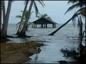
When remembering the earthquake of December 26, 2004, most people think of the tsunamis, but land submergence also had long-term consequences. (Photo copyright © Aron Meltzner.) |
| |

Part of the challenge was that the entire rupture didn’t happen instantaneously. Instead, the earth split like a zipper, progressing from south to north over several minutes. The seismic waves radiating from the southern part of the rupture were so intense that they essentially drowned out the waves from the northern portion. So when seismologists tried to trace the waves back to their point of origin, it was hard for them to tell how far north along the fault the rupture went.
A second problem was the lack of Global Positioning System (GPS) monuments in the region. GPS receivers pinpoint the precise location of a spot on Earth by integrating information from multiple satellites about their distance from the receiver. Scientists use GPS data to figure out how much the earth rose, sank, or shifted during a quake. Previous field research campaigns had installed about a dozen GPS monuments in the Andaman and Nicobar Islands, which stretch over about 700 kilometers northwest of Sumatra. “That’s as sparse as anywhere where someone has attempted to install a network,” says Meltzner. “Japan, although about twice the size, has more than a thousand.” |
|
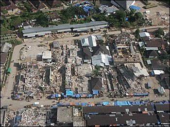
Many areas impacted by the December 2004 quake had to contend with both earthquake and tsunami damage. This aerial photo shows buildings turned to debris in the village of Gunungsitoli on Nias Island. (Photo copyright © Aron Meltzner.)
|
| |

As it turned out, the uncertainties in the seismic data and the region’s skimpy GPS network opened the door for some unconventional thinking about how to study earthquakes. When Meltzner returned to school in early January 2005, people were trickling back to campus after winter break. Scientists in his department started to give presentations about the quake, and some of them showed satellite imagery of affected areas. In addition to coastlines stripped of vegetation and strewn with debris from the tsunamis, some images hinted at dramatic changes in the elevation of reefs and islands.
In some locations, beaches seemed wider, and reefs more exposed. In others, the sea appeared to have swallowed reefs and shorelines, and water was ponded on land that was previously dry. When a megathrust subduction zone (a large area where one plate grinds beneath another) ruptures in an earthquake, the regions above the fault move up or down depending upon their position relative to the rupture. Meltzner realized that the images might be showing uplift and subsidence (sinking) from the quake; if enough of these changes were visible from space, he could use them to map the length of the rupture.
 Comparing Pre- and Post-Quake Images Comparing Pre- and Post-Quake Images
|
|
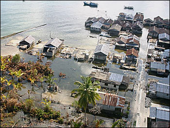
Even after the floods caused by the tsunamis retreated, some areas remained forever changed from submergence. The coastal village of Haloban on Tuangku Island (east of Simeulue Island) remained flooded after the massive quake lowered its elevation. (Photo copyright © Aron Meltzner.)
|

